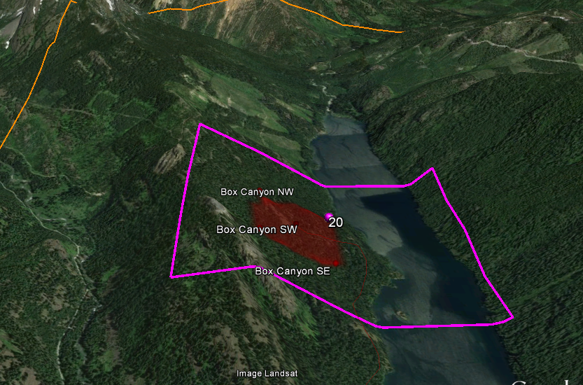
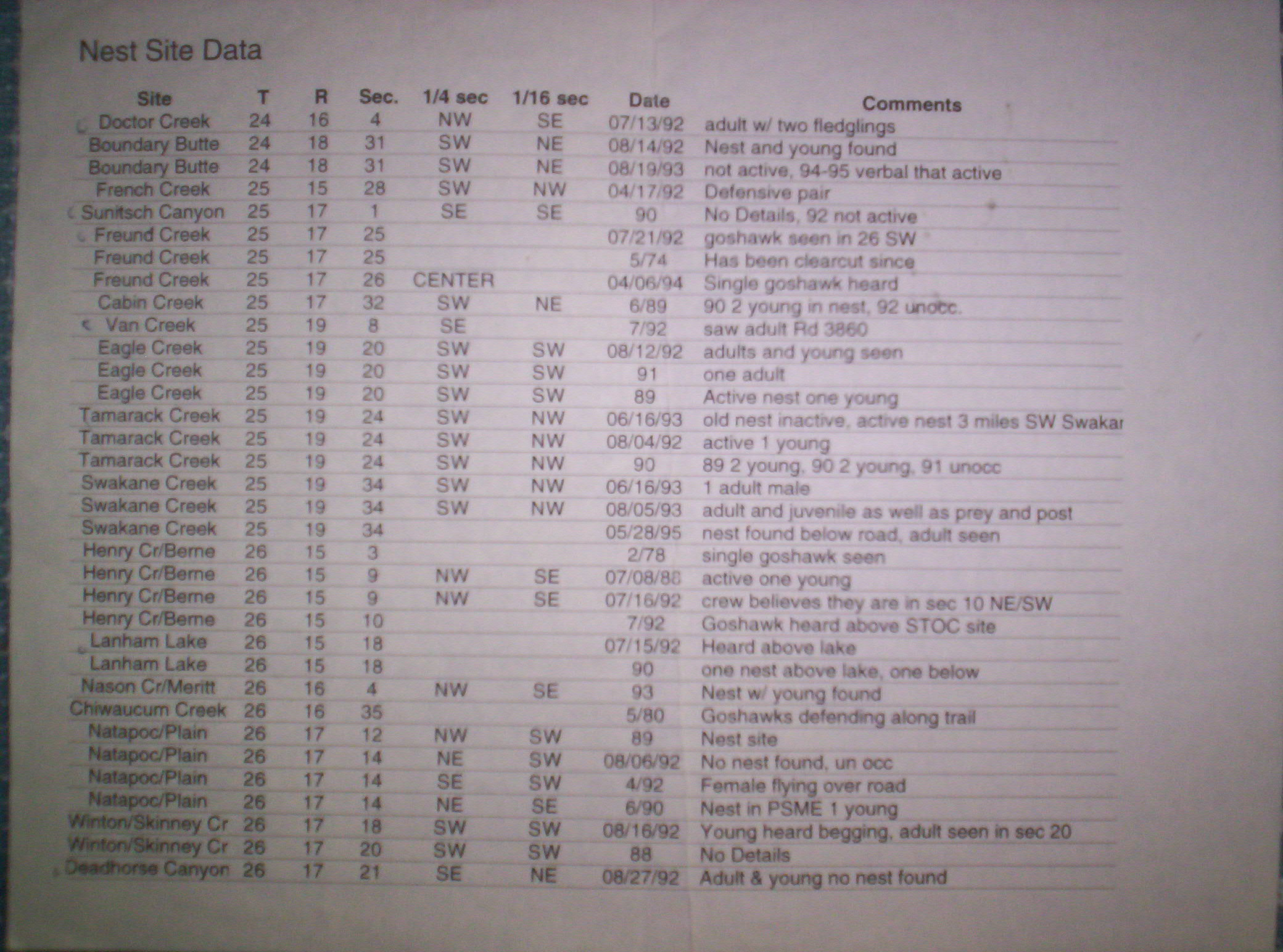
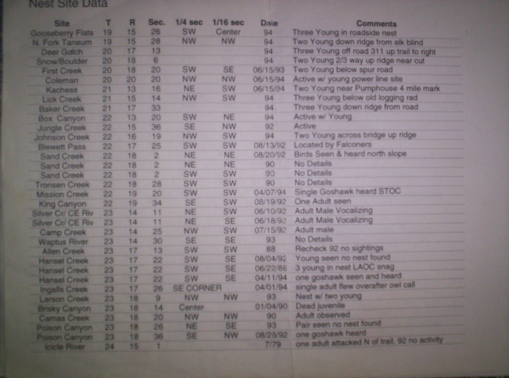
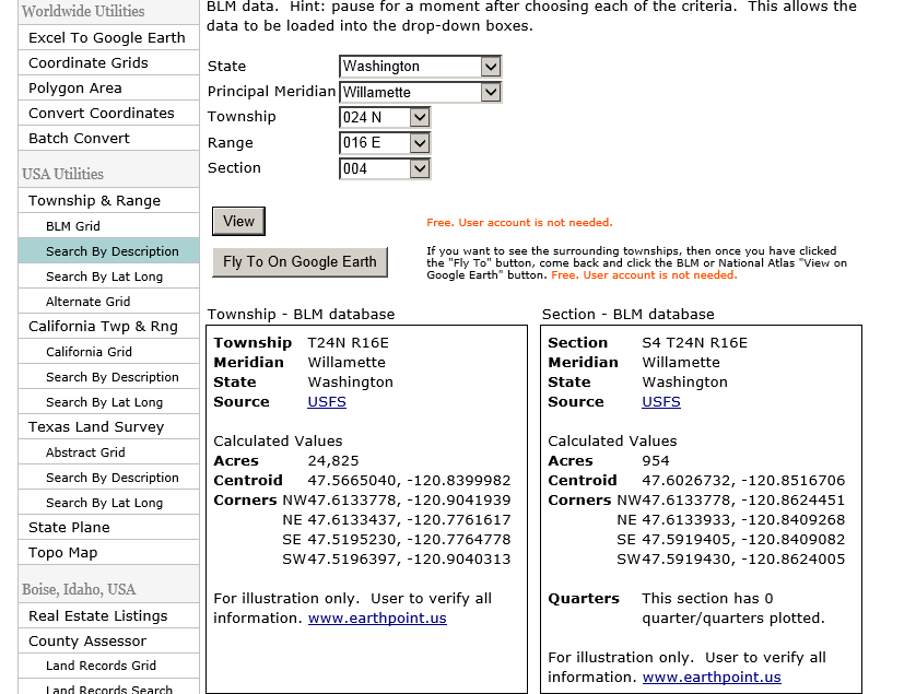
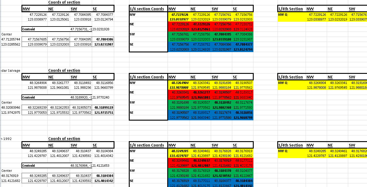
If you would like to share this with another person please ask and inform Dan or I, Thank you.

Note:

Expand content below by clicking on + boxes or Titles next to them, contract by clicking again.

    • Fullscreen window
      • Command

        Windows/Linux
        Keystroke(s)

        Result

        Move left Left arrow Moves the viewer in the direction of the arrow.
        Move right Right arrow Moves the viewer in the direction of the arrow.
        Move up Up arrow Moves the viewer in the direction of the arrow.
        Move down Down arrow Moves the viewer in the direction of the arrow.
        Rotate clockwise Shift + left arrow Rotates the view clockwise. The earth spins counter-clockwise.
        Rotate counter-clockwise Shift + right arrow Rotates the view counter-clockwise.
        Show/hide Overview window CTRL + M Displays or closes overview window.
        Tilt up Shift + left mouse button + drag down, Shift + down arrow Tilts the viewer toward "horizon" view.
        Tilt down Shift + left mouse button + drag up, Shift + up arrow Tilts the viewer toward "top-down" view.
        Look CTRL + left mouse button + drag Perspective points in another direction, as if you are turning your head up, down, left or right.
        Zoom in Scroll wheel, + key, PgUp key Zooms the viewer in. Tip: to use the 'Page Up' key, make sure 'Num Lock' on your keyboard is off.
        Zoom out Scroll wheel, - key (both keyboard and numpad), PgDn key Zooms the viewer out. Tip: to use the 'Page Down' key, make sure 'Num Lock' on your keyboard is off.
        Zoom + automatic tilt Right mouse button + drag up or down Zooms the viewer in and automatically tilts your view as you approach ground level.
        Stop current motion Spacebar When the viewer is in motion, stops movement
        Reset view to "north - up" n Rotates view so that view is 'n'orth-up.
        Reset tilt to "top-down" view u Resets angle to view scene in "top-down" or "'u'p" mode.
        Reset tilt and compass view to default r 'R'esets angle to view "top-down" and rotates to "north-up" view. Use this feature to orient the earth in the center of the viewer.

        Tip - Use the ALT key in combination with most of these keystrokes to move more slowly in the indicated direction.

    • This Google Earth plugin only seems to work with Firefox or Chrome. After installing I think you need to restart the browser in order for it to be loaded. Do it, it is worth it.
    • If you only have Internet Explorer I would suggest broadening your horizons or downloading Google Earth and using the .kmz file below.
    • You can try using IE and enable compatibility by going to -> Tools-> Compatibility view settings-> Add-> Close.

      However this screws up all of the nifty collapsing lists I have going on here...


    • View Alll Goshawks in a larger map

      Google Maps only shows some waypoints at a time...

      • I used TRS data (Township Range Section) from historical nest sites to find the corresponding 1/4, and 1/16th sections
      • Then I converted these to GPS coord,

      • To aid in 3D mapping and to increase the odds of actually being in the right place in the woods while searching for Goshawk nests.

      • I converted township and range using this website-> http://www.earthpoint.us/TownshipsSearchByDescription.aspx
      • Then I saved each corner coordinate into the excel doc

        to split up the section (~600-800 acres) into quarters (150-200 acres) and 1/16ths

        (to get around 30-50 acres for each search area)

        assuming 1/16th section data is known...

      • Each Corner Co-ord is inserted into Excel document with formulas
      • Then Each column will calculate 1/4 section (colored backgrounds) and 1/16th section (Corners Each Column, 1/16th section in rows)
      • Make master list with GPS coord's by pasting nearest known location (1/16th section) Coor-d's under the "Coords of section" data , to find each Corner and center
        • latitudes have positive values to make the math easier, type in a negative into the gps
        • Excel may make you paste data as values, right click "123" (pasting 1/16th section coords into excel).
      • I put each coordinate into Google Earth for each site, Center and NW,NE, SW,SE corners
      • Save all points for a site under a folder with the site name,
      • organize by alpha and /or region
      • Then I can export to google maps or GPS
      • You can use this website to convert .kml or .kmz into .gpx (Which can then be downloaded into a GPS)
      • http://www.gpsvisualizer.com/
      • Hopefully this will help you to get to the right place at the right time. . .

I would love to be able to do this with Goshawks this next spring->

Click here for a better quality video (.wmv 600 Mb) and remember to make it full screen or choose HD quality on Youtube.

I put up some remote cameras last year and would love to continue this experience if your would like to help feel free to:


Home
Falconry
Hawking
Info
Gallery
RT Hwk
Eyass Gos's